Magnetometers produce ultra-high-res imagery of NT terrain
Client
Project Status
Location


Sensorem has set a new benchmark for safety-conscious, ultra high-resolution imagery for mineral exploration, using drone magnetometer surveys to conduct low-level airborne geophysical surveys in the Northern Territory. Covering remote areas at night, Sensorem’s results exceeded client expectations and delivered high-quality imagery that traditional surveying methods cannot compete with.
What is a magnetometer?
A magnetometer measures magnetic strength and magnetic direction, which helps users locate mineral deposits, or buried objects with an iron content. This allows it to identify potential locations for large deposits and sites of value, making it an essential tool for mineral resource exploration.
Different types of magnetometers
Magnetometers come in a variety of different sizes and complexities, the most well-known of which is the simple compass.
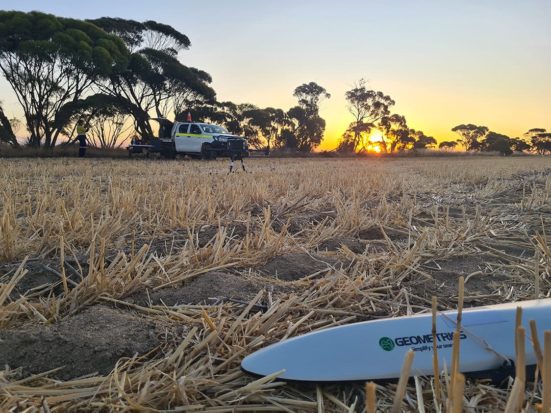
Each type of magnetometer has its own principles and applications; the two main categories are vector magnetometers, which measure field direction and scalar magnetometers, which measure field magnitude. The Geometrics MagArrow II Magnetometer which Sensorem used for this project is a scalar magnetometer.
What did the client need?
We conducted a thorough airborne geophysical survey to help de-risk early-stage exploration and better understand the subsurface conditions across their mineral prospect. The goal was to identify magnetic anomalies that could indicate the presence of valuable ore bodies, particularly in areas that were previously unmapped or inaccessible by traditional ground-based methods.
By capturing ultra-high-resolution magnetic data using drone-based technology, we enabled the client to refine their exploration model, reduce unnecessary drilling, and focus their efforts on high-potential zones. This approach not only accelerated their project timeline but also helped optimise resource allocation across the broader tenement.
How did Sensorem carry out data collection for this project?
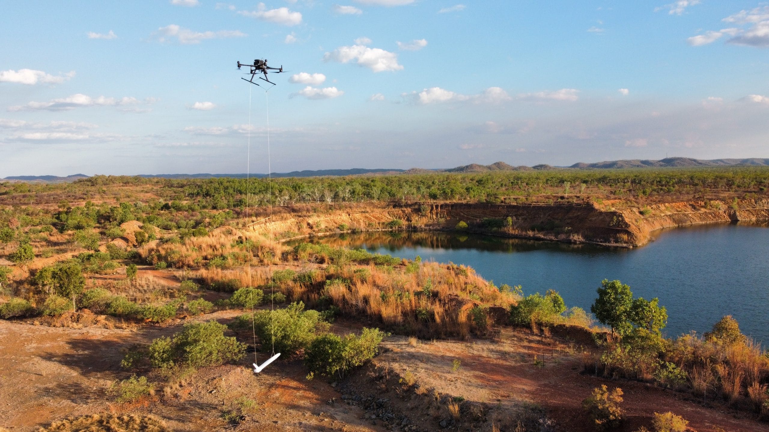
Sensorem conducted a low level airborne geophysical survey for PNX Metals at their Mt Keppler site, in the remote Northern Territory. This was the second drone magnetometer survey we conducted for PNX Metals in the NT, with another successful survey completed in 2022.
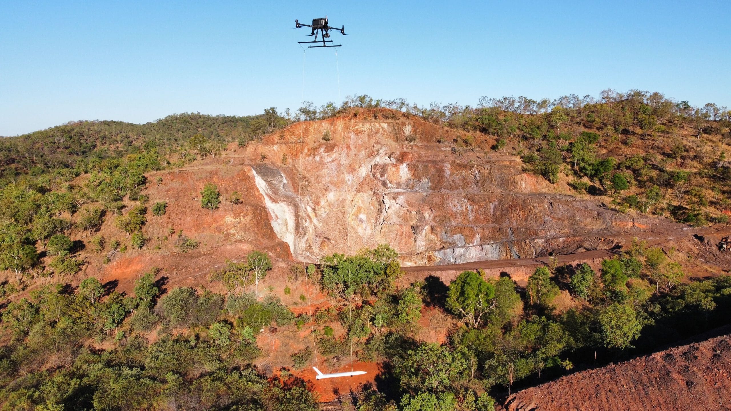
The survey was conducted using a Geometrics MagArrow II Magnetometer in a towed ‘bird’ arrangement, which means the equipment was towed behind an aircraft. The MagArrow II is the second generation of the best-selling UAS-enabled magnetometer and it’s setting a new standard for UAS magnetic surveys.
We used a Digital Elevation Model (DEM) in the flight mission planning software to ensure precise altitude control. The drone waypoints were calculated via a specified Above Ground Level (AGL) tolerance value of 1.5m.
Much of the data captured for this survey took advantage of Sensorem’s CASA approval for night operations, with flights conducted between local time last and first light, to improve flight efficiency with reduced wind and lower ambient temperatures for personnel and equipment.
A GEM base station magnetometer was used for the entirety of the survey, to provide diurnal correction and monitor for any environmental anomalies. The base station was placed in the same location at the beginning of each survey, with a controlled equipment setup to mitigate measurement variation. The location was specifically chosen due to its minimal magnetic gradient and isolation from potential external magnetic influence.
What are the advantages of a drone magnetometer survey?
Drones provide a balance between survey resolution, area coverage, signal strength and data quality that traditional airborne and ground-based methods cannot achieve.
Ultimately, conducting this magnetometer survey and delivering output over and above the client’s expectation required around 1,526 km of straight line flying, while maintaining a constant altitude of 40m AGL. Magnetic intensity is inversely proportional to the distance between source and sensor, so there is great benefit to flying low. By flying closer to the earth’s surface, drone-operated magnetometers can provide higher resolution data.
The closer proximity allows for weaker magnetic bodies, near-surface features, and smaller, focalised bodies to be more recognisable. It also allows improved recognition of magnetic gradients for better identification of bodies, features, ridges, and vein systems. Drone magnetometer surveys can complement existing survey data to focus and improve the results for a specific location.
Sensorem magnetometer surveys provide ultra-high-resolution imagery that meet and exceed industry standards, enabling higher resolution and low noise threshold data and excellent altitude and terrain-following control.
What were the challenges of using a magnetometer?
Flying at lower altitudes does introduce difficulties, even for drone systems. Objects are harder to avoid and there can be issues with power lines or birds, leading to avoidable accidents. These challenges were overcome by our highly experienced drone operators. Drones provided the balance between survey resolution, area coverage, signal strength and data quality that traditional airborne and round-based methods cannot achieve.
Was a magnetometer more effective than other survey methods?
We believe so, yes. Using a drone to help produce a magnetometer survey allows access that traditional surveying methods cannot compete with. It allowed the results to exceed the client’s expectations.